Low Cost Amateur Aerial Pictures with Balloon and Digital Camera - Principles and General Procedures
|
|
Why do we need quick and cheap OrthophotosDigital aerial images provide multi-scale, multi-temporal, and multi-spectral properties thus production of the images becomes a main trend in the field of GIS and photogrammetry. Geo-referenced or rectified aerial photo image maps are getting important due to its low cost and fast production. Recent spatial information of fast changing environments is crucial for several administrative, planning, observation and assessment reasons.
|
|
|
Processing amateur digital aerial picturesIn most cases mosaic images were produced based on several single pictures using standard remote sensing mosaic production techniques. Firstly, an atmospheric correction had to be carried out, a step which can be skipped in low altitudes. Secondly, images were enhanced before mosaicing.Geo-referenced digital images are transformed to the local co-ordinate system, by warping the digital images to fit either to a base map or other ortho-images. Ortho-rectified pictures are processed and shifted to an air triangulation model using the method of surveyed ground control points. Ortho-rectified photos based on digital elevation model techniques are considered to offer higher applicable precision as the accuracy level of simple handheld GPS. Using two GPS with post processing an accuracy rate of less then 1.0 m can be achieved. There are significant benefits in ortho-rectified photography over simple geo-rectified images used here, but there are also significant variations in cost. Ortho-rectified photography has the potential to be more accurate while the photographic image is draped over a digital terrain model based on land survey control. The main benefits are of improved accuracy in horizontal as well as vertical plan shape, particularly where there is high relief across the area. But this accuracy again is strongly dependant upon the accuracy of the DTM used as base model. The most accurate acquirable DTM for Cambodia is the SRTM 50 m grid with provides high spatial resolution with a grid of interpolated levels at 1m intervals. Unfortunately, it has got some significant miscalculations in huge flat lowland areas like the Cambodian floodplain or the Tonle Sap Lake and its tributaries. Only photogrammetrically derived detailed DTM or air triangulation models would provide higher precision and better resolution. This may allow orthophotos to be produced with a plan position accuracy of approx. +/-1m, but was not applied due to limited data processing capacity, which is much more cost effective and requires higher statistical and remote sensing software capacities. |
 |
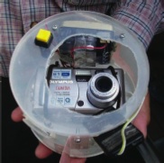
Types of amateur digital aerial picturesGeo-referenced digital images are transformed to the local co-ordinate system, by warping the digital images to fit either to a base map or other ortho-images. Photo 1: Digital Camera with GPS receiver
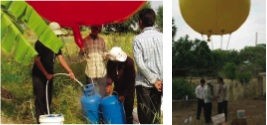
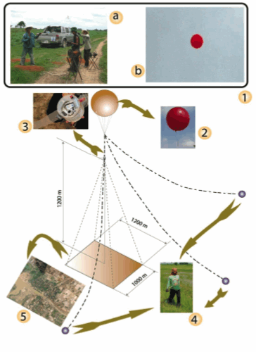
Hydrogen balloon techniqueThe normally used balloon is made of light PE material with a maximum size of inflation of about 2.5 m. It is fixed and controlled via 6-8 non flexible offshore fishing lines adjusted at special fixation tongues on the bottom of the balloon. As inflation gas helium or hydrogen can be used. While helium is still very expensive and problematical to acquire in developing countries, hydrogen can be produced locally. The advantage of hydrogen is its uncomplicated production on the test site based on aluminum cans, water and a special salt which are easy to transport and assembly just beforehand its application (see Photo 2). The critical danger of hydrogen is its chemical unstable reaction prone to dangerous explosion and inflammation. The chemical reaction formula with the resulting hydrogen gas and Natriumalbumiat is given as follows:
|
 |
A non calibrated simple 7 megapixel (or better) digital camera is fixed in a light plastic holder together with the infrared remote control and a GPS receiver. The camera is activated by a special electronic clock and is set to take pictures every 10 seconds synchronized with a GPS receiver (see Photo 1). Resulting pictures will have a ground resolution below 1m up to 5-10cm. Balloon levels of 50 to 400 m above ground with different resulting ground resolution are possible with decreasing positioning accuracy of picture nadir points in higher altitudes. The estimated price of the complete photo acquisition bundle add together around 2500 US$ including camera and GPS receiver. Problematic are the balloon sensitivity to wind speed over 3m/sec and explosive inflation gas.
Photo 2: Balloon filling with Hydrogen Gas
Field data acquisitionFor photo orientation and precise image mosaics ground control points have been measured using post processing differential GPS in comparison to simple hand held GPS measurement. Additionally, a combination of Ground Control Points in combination with image to image rectification technique based on a geo referenced Spot satellite image is considered to provide relative accuracy below average handheld GPS errors.
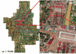
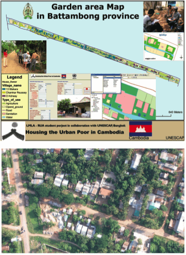
Photo geo-referencingPhoto geo-referencing rotates and stretches images to match the balloon nadir position, corrects further positioning errors and minimises image distortions. A first order transformation will allow the unregistered image to be rotated, shifted, or scaled, but will not deform the image to best match the links. The second order polynomial transformation allows some distortion of the unregistered image, and should be used if the unregistered image does not quite align with the existing registered map. A third order polynomial transformation is only applied to maximum distortion, or “rubber sheeting”, of the unregistered image to match the ground control points. This is necessary for images with larger deformation and where ground control point links are poorly aligned after rotation. The majority of balloon images where transformed and re-sampled with 25 to 40 ground control points and a third order transformation method. Transformed and geo-referenced images are then joined into mosaics and ready to be used in further interpretation, mapping and classification processes (see Figure 2 and 3). Mosaic tiles produced in TIFF files, have been found to produce the most versatile images for manipulation within GIS. During mosaic joining cloud areas are masked or extracted and substituted with overlapping areas of neighbouring images. Figure 1: Image acquisition plan and detailed image of Battambang, Cambodia
Figure 2: Garden-strip in Battambang with 10 cm ground resolution
Picture scales and mapping techniquesGeo-referenced aerial balloon pictures can be viewed or plotted within a GIS, at scales of 1:5000 to 1:10.000 without any significant loss of image quality. Although a higher level of urban architecture plan shape accuracy can be achieved by mapping from even higher resolutions, the resulting image quality exceeds existing and available conventional aerial photos. Figure 3: Model of image acquisition technique
Pictures could be even used to count the number of umbrellas of temporary market sellers around market areas. Especially in remote open forest regions the achieved data quality offers new opportunities for inventories and detailed degradation studies.
This photo-scale appears to be optimal, for production of geo-rectified images for use in urban and regional planning as well as environmental observations. It produces reliable plan shape data and horizontal resolution for analytical remote sensing data interpretation and on screen digitizing for operational purposes. Even though detailed vegetation or environmental change detection based upon this method is limited, this accuracy is acceptable at all levels of urban planning and change detection of any kind of construction in the urban environment like spontaneous settlements as well as informal construction. Therefore, it is an appropriate technology for urban planning and construction verification in cities with small to limited budgets.
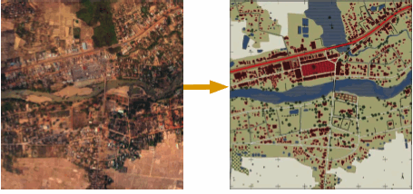
Figure 4: Result of the orthophoto mosaic / map after identification and classification
|

