Low Cost Amateur Aerial Pictures with Balloon and Digital Camera - Example: Low Cost Orthophoto Production in Battambang Town, Cambodia
 |
Since 1992 several aerial photos missions have been carried out in Cambodia by contracted international remote sensing companies funded by different international grants and loans. However, most of this spatial data is collected in some Cambodian ministries while a transparent and administratively controlled access or exchange to remote sensing data, even among different ministries is not yet established in Cambodia. In contrast, recent spatial information of fast changing environments is crucial for several administrative, planning, observation and assessment reasons. Interpretation of high resolution remote sensing data is tempting in the frame of land management, land use classification, degradation assessments, urban and infrastructure planning as well as monitoring of rapid land cover changes in any kind of environment. Photo 1: Camera with GPS receiver
Photo 2: Filling of the Baloon with Hydrogen
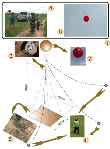
The aim of this methodology is to incorporate and geo-reference unregistered data from a balloon, ultra light or delta born aerial photography to a coordinate system topographical map. The resolution quality of low-altitude aerial photography far exceeds that of other surface imagery such as Spot or even Ikonos satellite imagery, making it a valuable tool for urban planners, environmental scientists and nature protectionists. Detailed spatial information below 1m pixel resolution such as vegetation associations or housing types is not detectable on inexpensive but larger airborne imagery while high resolution Quickbird images are often not available or cloud covered for Cambodian regions. Detailed construction types and multi-temporal spatial features such as vegetation vitality and small scale clearings are not easily to detect on conventional satellite imagery. Due to geo-referenced aerial photos these features could easily be digitized into separate layers using GIS mapping techniques. However, amateur aerial photos do not generate automatically compass orientation nor any spatial reference information or exact scale. Geo-referencing or ortho-referencing methods needs to be applied, i. e. using referencing tools in ArcMap, Erdas Imagine, ENVI, PCI or any other Remote Sensing software which allows the user to align geographically unregistered data to data that exists in geographical coordinates. Figure 1: Model of image acquisition technique
|
 |
Ortho-rectified photography has the potential to be more accurate while the photographic image is draped over a digital terrain model based on land survey control. The main benefits are of improved accuracy in horizontal as well as vertical plan shape, particularly where there is high relief across the area. But this accuracy again is strongly dependant upon the accuracy of the DTM used as base model. In contrast, Ortho-rectification is far more difficult, requires more RS or geodetical user capacity and a considerable amount of digital calculation power regarding the amount of data being handled.
Photo 1: Market Area Battambang 1:1.000
Photo 2: Degraded open forest area 1:5.000
The topic is a seasonal to 5 years change detection observation of a degraded open forest environment for a special observation site of forest re-growth and vegetation recovering (see Photo 2). Further images were taken for simple area observation and base maps of two national universities in Cambodia (Royal University of Agriculture and Preak Leap National School of Agriculture) in the surrounding of Phnom Penh. But one of the most advantageous applications of this method is the production of base maps for medium scale infrastructure projects like bridge and road construction, hydraulic engineering and irrigation projects in the Cambodian lowlands.
Figure 2: Image acquisition plan for and detailed Battambang images
Geo-referenced balloon borne amateur aerial digital photos can be an effective replacement for the traditional cost expensive orthophoto image production in land cover analysis and urban planning projects as well as it is practical for field verification surveys as well. With a non-metric, small, relatively inexpensive digital camera, and inexpensive portable balloon, ultra-light or kite solutions large digital aerial photography is now a suitable technique for developing countries to acquire inexpensive planning information. There is no inevitable requirement for an expensive camera equipment and high-level camera calibration. Once they are geo-referenced, they can be used as a map layers in any GIS and remote sensing application. They can be directly geo-referenced and viewed like maps without extra software for orthophoto re-sampling or other sophisticated image rectification and image enhancement technique. The major advantages of digital aerial photography are that digital images often have much higher resolution than conventional aerial photos. As a result they are efficient both in terms of time and cost.
|
 |
Balloon or ultra-light images offer the following additional detail, relative to conventional orthophoto mapping:
|