Identification of Desertification Prone Areas - Example: Identification of Desert Prone Areas in Lebanon
 |
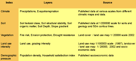
Defining Desertification Prone Areas in LebanonThe Lebanese government has recognized that the overall process of economic development is closely bound up with environmental conditions, and is therefore focussing strongly on activities that will protect the environment and improve the management of natural resources. During and immediately after the war in the Lebanon, planning rules or any form of sustain-able development planning were totally lacking, and this has ultimately led to uncontrolled development as far as land use is concerned, accompanied by the over-exploitation of natural resources. The central problem is chiefly that land use has been misdirected, and is now inappropriate to the climatic, physical geographic, socio-economic and ecological conditions. The key causes of this central problem are the lack of any planning for appropriate land use and organizing the necessary supervision, and inadequate institutional structures responsible for issuing rules and supervising adherence to them. The key impacts of the central problem include extensive building in rural areas, accelerating deforestation and inappropriate use of pastures, ultimately leading to an increase in land degradation. In order to be able to determine the degraded land in the country, the method to define desertification prone areas was applied. The indices and their pertinent data layers, which have been selected for Lebanon, are as follows: Table 1: Information layers used in evaluating DPA and related sources
|
 |
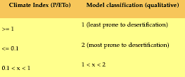
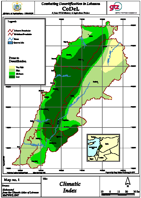
Climate:It is assessed on the basis of how it influences water availability to the plants. Consideration has been given to the amount of rainfall, potential evapotranspiration and thus aridity. In particular the selected information layers are the annual precipitation and potential evapotranspiration. The climate index is the ratio of the yearly precipitation over yearly potential evapotranspiration calculated using the Penman method (P/ETo). Table 2: Defining the climatic index
|
 |
Map 1: Climatic Index
|


