Updating Maps using Global Positioning Systems (GPS) - Brief Description
|
|
The Global Positioning System (GPS) system is a network of satellites orbiting the earth that continuously transmit coded information. The coded information transmitted makes it possible to precisely identify locations on earth by measuring the distances from the satellites through triangulation. The system was originally designed for and used by the U.S. Department of Defense. Since the early 1980’s the technology has been made available for civilian use. Initially, the quality of information available for civilian use was reduced. This was done by scrambling the signal of the satellites (“Selective Availability”) and therefore reducing the accuracy of civilian handheld GPS to about 100 m. In May 2000 the then President of the USA decided to discontinue the technology of “Selective Availability” and the accuracy of handheld GPS has been increased to 10 m. More expensive systems with higher and sophisticated processing procedures can increase the accuracy up to a few centimeters. This has opened up a market for a multitude of new GPS-applications.
A handheld GPS can measure and log positions on Earth by triangulating the position of satellites
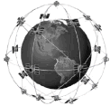
21 activated satellites are continuously sending unique signals while surrounding the Earth |

